The Lollandian Alps
Lolland is known for its flatness, but the hills of Ravnsby Bakker are the complete opposite. They form a very distinctive and utterly beautiful undulating landscape.

Route description
At the end of the last ice age, around 20,000 years ago, the ice moved back and forth in the area of Ravnsby Bakker, forming large hills and valleys. These movements also resulted in the deposition of some large blocks of ice under the ground, which melted more slowly than the rest of the ice. These blocks are called ’dead-ice’ and when they have finally melted, they leave large, deep holes, like at Ravnsby Bakker.
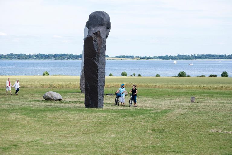
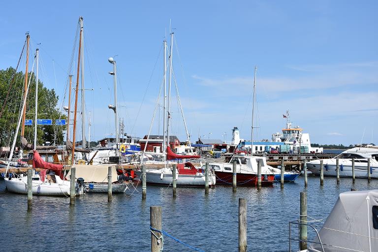
The bicycle route starts in the attractive harbour town of Kragenæs, which connects Lolland to Fejø and Femø by ferry. From here, the tour continues to the Dodekalit - a spectacular world-class sculpture which is still under construction. Enjoy the magnificent view of the waters called Smålandsfarvandet.
After a visit to the castle ruins of Ravnsborg, the tour continues towards a flatter landscape - Ugleholt Forest and the tour’s halfway mark of Vesterborg.
Vesterborg is a good place to have a well-earned rest at the church, and to enjoy your packed lunch. Afterwards, ride on to Pederstrup, Reventlow Parken and Kong Svends Høj burial mound - a very special passage grave that is well worth a stop.
Even though the bicycle route is called ’The Lollandian Alps’, it is absolutely suitable for everyone. Don’t miss out on this lovely bicycle route!
Practical information
The bicycle route is signposted with blue signs - you just need to follow the mountain symbols: ”bjergene”.
Along the bicycle route, you will also encounter signs with symbols and numbers from other routes; The Monk Road (89), Naturlandet Rundt (N), Forest, Coast and Wine (trees) and The Islands By Bike (ferry).
We recommend following the route in the direction that follows the numbers on the map. The entire length of the bicycle route is signposted in this direction.
Refreshments only available in Kragenæs, so remember to bring your own supplies. There are many lovely spots for a picnic with a view
Public transport
The bicycle route starts at Kragenæs Harbour. You can get to and from the harbour with a bus from Maribo or Nakskov. Your bicycle can be brought on the bus. Naturlandet recommends Rejseplanen for bus and train schedules.
Experiences and attractions
- Kragenæs Harbour: Idyllic marina and campground on the shores of the waters called Smålandsfarvandet, with a regular ferry connection to the islands of Femø and Fejø.
- Dodekalitten: Dodekalitten means twelve stones in Greek and is a totally unique monument still under construction. When complete, it will comprise of 12 stone sculptures measuring between seven and nine metres in height.
- Ravnsby Bakker: This undulating area of natural beauty was sculpted during the last ice age. The area consists of hills, valleys and dead-ice sinkholes, and large parts of the area are protected. The largest dead-ice sinkhole is Møllelung, measuring 900 by 300 metres.
- Ravnsborg: The remains of the Ravnsborg castle lie on an 18-metre natural high bank stretching out to the coast. The castle was built around the year 1330.
- Vesterborg: The lake of Vesterborg Sø is connected to Nakskov Fjord by the Halsted River and 1000 years ago, perhaps people could have sailed all the way to Vesterborg. Vesterborg Sø and Halsted River were formed in the last ice age. In Vesterborg, you will also find a lovely village church, which is unusual as the bell tower was built on the opposite side of the church compared to other churches.
- Reventlowparken: This lovely park lies in the grounds of the Pederstrup manor house. In the park, you can discover and enjoy numerous traces of 300 years of history. The main building of the manor has been converted into a museum, dedicated to the Danish statesman C.D.F. Reventlow.
- Kong Svends Høj: One of the most famous passage graves in Denmark. The burial mound is approximately 21 metres long and 15 wide, which is unusual as they are normally round. The chamber in the mound is 12.5 metres long, which makes it the second-longest in Denmark. The passage grave was built in approximately 3200 BC.

Gpx file
Download the gpx file for the route - The Lollandian Alps. The file contains the route's GPS data, and can be used to transfer the route to your Garmin watch and other apps. Remember you can find the route digitally in the Naturlandet Lolland-Falster app without needing the gpx file.